 |
||
Our Services
Since 2007 RS Geoiformatics Solutions Pvt. Ltd. is being involved in providing geospatial solutions to its esteemed customers across the world. Our team understands the value, acquisition, and analysis of geospatial mapping data and how it is applied to meet the needs and challenges of our valuable clients.
The following services are offered by RSGS:
Digital Aerial Triangulation
Planimetric Mapping
Digital Topographic Mapping
Digital Orthophoto process
LiDAR classification
UAV Image Process
3D Reality Mesh Creation
2D Mapping & GIS conversion
Training & Development
Assistance in dissertation to university students
Aerial Triangulation

RSGS performs Digital aerial triangulation utilizing state-of-the art software to provide a highly accurate analytical solution.
click for more information
Planimetric Mapping

Planimetric mapping shows only horizontal features on a plane surface, without elevation contours to depict the terrain.
click for more information
Digital Topographic Mapping
 Digital Elevation Model (DEM) is the collection of mass points of elevations either manually or automatically using image correlation algorithm. As the DEM does not show the actual
click for more information
Digital Orthophotography
 A digital orthophoto is a reproduction of aerial photograph, which is fully rectified to remove distortions. The removal of these distortions results in imagery becoming a true-scale
 click for more information
Mapping & GIS Conversion

Digital orthophotograhs have become an accepted inputs for base map for geographic information systems for a wide variety of uses, including:
click for more information
LiDAR (Light Detection And Ranging) Classification
 LiDAR technology provides one of the most accurate, expedient and cost-effective ways to capture wide-area elevation information. With increased data collection....
 click for more information
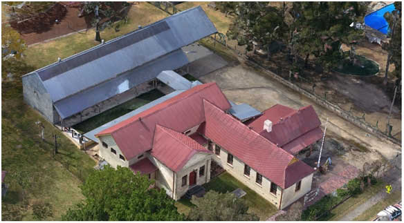
UAV Image Process
Aerial dataset acquisition from UAS/UAV/Drones (Unmanned Aerial System/Vehicle) can be used for different purposes including.....
click for more information
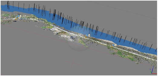
3D Reality Mesh Creation
 Aerial image acquisition from UAS/UAV/Drones (Unmanned Aerial System/Vehicle) is used for 3D reality mesh creation more economically now-a-days.....
 click for more information